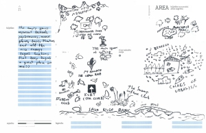
Zagreb, Croatia
 Zagreb, Croatia
Pop. 804,200
Croatia was first settled in the 7th century by Croats and Zagreb, later established in 1024, and became the second city to the former Yugoslav republic. Because Zagreb is the capital and largest city of the republic of Croatia, it is the seat of the central government and administrative bodies. The city was first divided into two core centers, with clergymen on one side and farmers and merchants on the other, and then united in the 1800s through the main city square. Croatia became popular for its prime location for transportation between the Adriatic Sea and central Europe. As the city became more connected through railway lines, it adopted the suburban block pattern of other central European cities. More residential housing became available after World War II, resulting in a large population increase and the clustering of the working class.
- Project Dates: June 14-20, 2007
- Exhibition: Urban Festival
- Collaborating Partners: Hana Dvornik, Sonja Soldo of BLOK, University Art History students, Ryan Griffis, Booksa, Marko Sancanin, WHW, MaMa, Tourism Office, Ivan Zaluski, Danko, Dejan Krsic
- Notes: The first attempt to adapt NPA outside Chicago, the Zagreb efforts occurred at the invitation of BLOK, the organizers of “Urban Festival” annual public art convergence. Because it was our first experiment, Dave Pabellon and Daniel Tucker acted as the map makers more than in future NPA efforts, working under the name “The Speculators” as an attempt to reflect the research process conducted by outsiders looking in. The initial map was designed to be blank with no outline of the political boundaries of the city limits because our hosts suggested that no Zagrebians would recognize their city that way and they encouraged us simply to indicate the rough shape of the river and the location of the city center. The process unfolded over one week where informational walking tours on ecology, urban planning, art, and political history were led by local residents. The Speculators also went on drifts throughout the city, talking with random residents at markets about the travel routes of their goods, led map-making workshops with a student group, interviewed urban planners about the legacy of socialist state planning on the current urban design and solicited numerous thematic maps from residents around the local academic and arts communities. The results were compiled over the course of the week into a “critical tourist” guide to zagreb which was printed and distributed locally at the university and tourism offices. A lecture on mapping and the work of AREA Chicago was held at upon the completition of the visit at Booksa, a leftist bookstore and cafe where a window display of the blank map of Zagreb was presented in the store-front that invited passer-bys to record important local cultural spaces and historical events by drawing directly on the window pane.