Boston, Massachusetts
Boston is the capital of Massachusetts and one of the oldest cities in the United States, dating back to 1630 when it was first founded by Puritan colonists from England. At first the area only encompassed the Shawmut Peninsula but its borders have expanded due to land reclamation (now it is 89.6 square miles). Historically, Boston has been a significant site of resistance, notably through its major role in the American Revolution as site of the Boston Massacre and Tea Party. The city used to be the world’s wealthiest trading port, but its shipping industry was surpassed by manufacturing after the Embargo Act of 1807. The economic sectors again shifted in the mid 20th century after large-scale urban renewal, and today are largely education, health, technology, and finance. With this shift came extremely high costs of living due to gentrification.
- Project Dates: July 28th, 2010
- Exhibition: Lecture on activist mapping practices at DS4I
- Collaborating Partners: James David Morgan of Groundswell and Kenny Bailey and Lori Lobenstine of Design Studio for Social Intervention
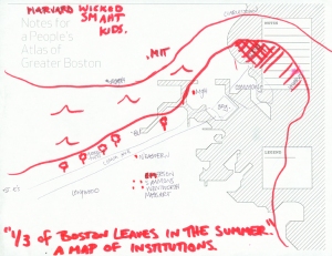
- Notes: Invited to give a lecture about activist mapping at the DS4I space, Daniel Tucker worked with Dave Pabellon and Groundswell to develop a NPA project to release at the lecture. The inner core of Boston did not encompass the range of places that made up most people’s impressions of what constitutes Boston and so the map was expanded to be a more open-ended definition of “Greater Boston.” The maps were distributed and filled out on the spot at the lecture and distributed via the Groundswell blog in the days leading up to and following the public event.
Download all the maps here.
